 |
Lawrence Township in the 1960s
| Home |
| The Boys |
| Landmarks |
| Suburban Archaeology |
| The Garage |
| Trenton |
| Nightlife |
| Radio & TV |
| This Page Last Updated: October 5, 2000 |
| This Page First Appeared: December 25, 1999 |
|
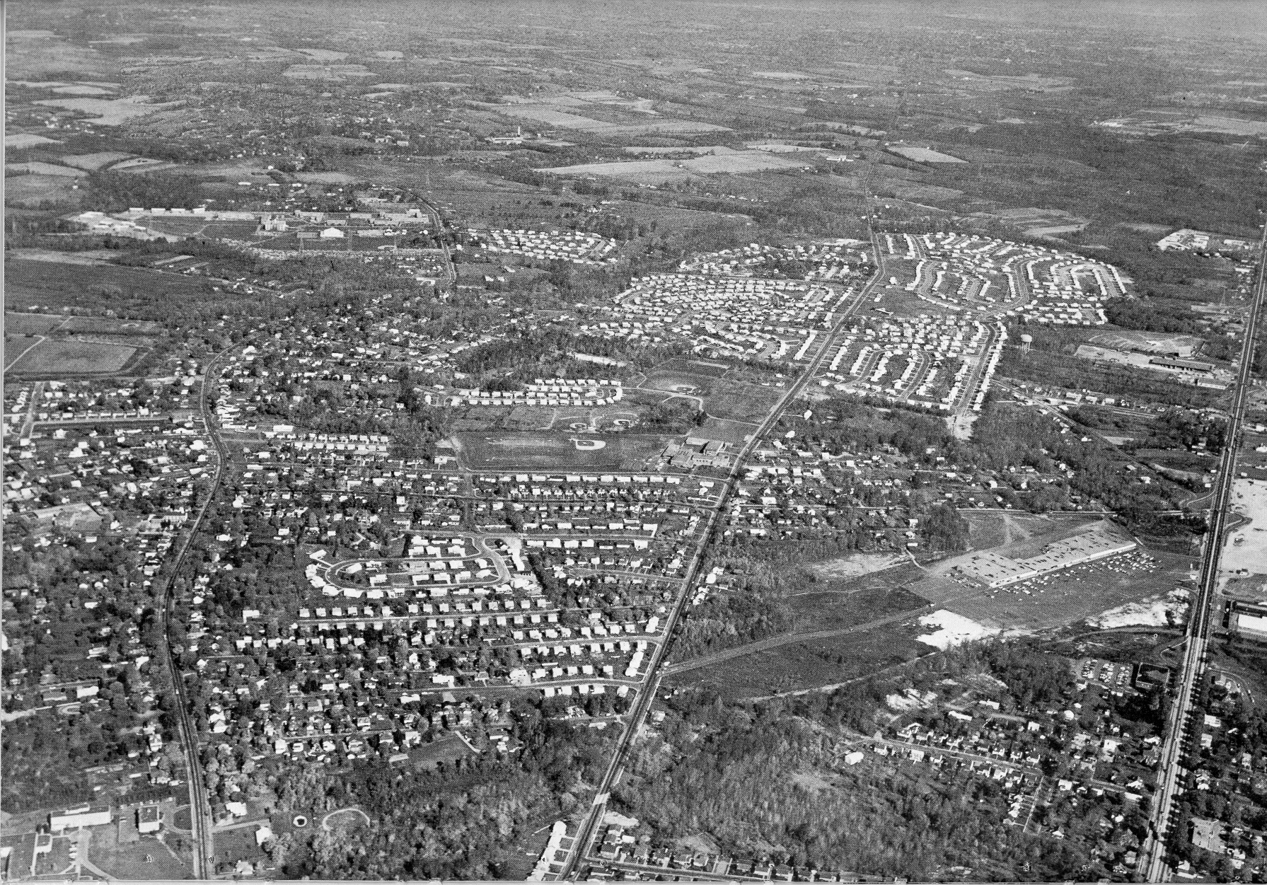
Route 206 on left; Princeton Pike at center; Route 1 at Right
See below to view this photo in full size
|
When the aerial photo above was taken in 1963, Trenton was still a commercial and professional hub for central and southern New Jersey. Development had radiated out from it, in the northern direction through adjacent Lawrence Township.
In 1963, the Allwood Drive neighborhood was part of the most recently developed section of Lawrence Township, a tract called Nassau Estates that was built in the late '50s. The Nassau development is very apparent in the photo as the leading edge of development northward from Trenton, sticking out into the fields and woods beyond. It looks like the broad part of a paddle, with Princeton Pike as its handle.
Follow Princeton Pike, in the middle, up to a slightly circular grouping of houses. You're there! The original Nassau Estates ("Nassau I") is to the left of Princeton Pike. Nassau II, still in construction at the time the photo was taken, is to the right. The names of the housing developments of the late fifties and early sixties -- in chronological order of completion Nassau I, Norgate, Pine Knoll, Nassau II -- are almost complely forgotten today. The "Nassau" name demonstrates the perceived desirability of the Princeton association even in the 1950's.
If you're interested in a close-up look at the lay of the land during the period this website covers, click on the photo above, or on the link near the foot of this page to see the photo in full size. A trip back to 1963.
A few things to keep in mind when you reach your destination in time. Route 206 is called Lawrence Road more commonly than now. Route 1 is still mostly known by its name from colonial times, Brunswick Pike, although people are beginning to refer increasingly to "Highway 1," especially relative newcomers in the recent developments. But Princeton Pike has always been Princeton Pike. There's no Lawrence High School. It won't be built for another 4 years. High school students south of Franklin Corner Road go to Trenton High; north of it they go to Princeton High. You'll find Lawrence Junior High School (today Lawrence Middle School) on Princeton Pike, just a shade to the right of dead center on the aerial photo. The fields around it are very recognizable -- except for the fields where the high school stands today. On the other hand, Notre Dame High School is there. Most of it makes it into the photo, in the lower left corner, together with the Chancery office of the Roman Catholic Diocese of Trenton. The Lawrence Shopping Center stands in its original form. Its first expansion -- roughly doubling the length of the original strip by extending it to the west -- is six years away. You can see the shopping Center clearly, even in the smaller photo above. It's on the right hand side, just below the top-to-bottom halfway point, and to the left of Route 1 -- I mean Brunswick Pike. In 1963 there is only one place in Lawrence Township north of the Brunswick Circle where you can see a movie. It's the Lawrence Drive-In. You can see it in the full sized photo by following Route 1 up from the Shopping Center. The big outdoor screen is hard to miss. And if you look carefully, you can just make out the shape of its unique sign by the roadside.The Texas Avenue jughandle at Highway 1 is there, and easily identifiable in the picture, but that's all there is -- no gas stations, stores, or post office. Across Highway 1 from the shopping center is Colonial Bowling Lanes. You can just make out the shape of the distinctive sign, which still stands today (and which you can see close-up on the Landmarks page of this website). You can also make out the shape of the original Lawrence Shopping Center sign on Route 1, opposite Colonial Lanes. You can see that sign on the Suburban Archaeology page. Glenn Avenue doesn't go all the way through to Texas Avenue, so don't try to drive it when you get to 1963 or you'll wind up in the creek. If you need a bank, don't bother going to the corner at Princeton Pike and Franklin Corner Road. There's nothing there except woods and a couple of old farmhouses. On the subject of driving, remember: there's no interstate bisecting Lawrence Township. No malls either. If you need something you can't get at the Shopping Center, head downtown (downtown Trenton -- people still spoke of "downtown" then) to any of the big department stores: Gimbels, Lit Brothers, Arnold Constable, Nevius Voorhees, Dunham's, John Wanamaker, Sears. All open for business downtown in 1963. In five years all except Sears and Dunham's will be gone. But where you're heading it's still possible to go to the store in Trenton. There's a lot to see. So put a tiger in your tank at the Esso station on Harney's Corner -- right across from the Ranch House burger place -- and take a cruise around the community of Virtual Allwood Drive by clicking HERE. See you in 1963.
|